Heavy Winter Weather Inbound
Posted: Fri Oct 27, 2006 4:28 pm
Some riders have been surprised by the arrival of cold fronts and more critically, squall lines. Some have been killed, others severely injured and yet others have lost and damaged gear.
There is no good reason in todays world why this should happen. Kiteboarders need to know and practice this stuff. Someday, most will except for those that may have taken themselves off the water through injuries or worse.
So, what fronts are inbound and how fast? When is the GOOD, useable wind likely to arrive after the squall line, if present? A few ideas been put together for the NE, it could easily be done for any other part of the USA and likely abroad in many cases as well.
First, are there any wx hazards forecast (NOTE: often there are not even though they blow through for kiters anyway. We NEED to know what be coming on our own without outside direction. It isn't rocket science.), checkout http://www.weather.gov/alerts/fl.html

Click the following for an animated weather map
http://www.hpc.ncep.noaa.gov/basicwx/day0-7loop.html

From: http://weather.sun-sentinel.com/

And radar
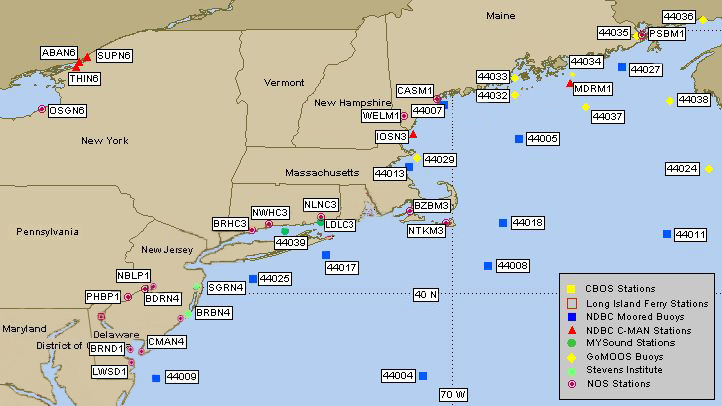
Click the following for an active version of the above wind speed chart for the NE
http://www.pdfamily.com/weather/buoy.php
You can also look at http://www.ikitesurf.com/ for realtime winds and other important weather information throughout the USA and beyond.
There is still more to know and check but this is a start.
FKA, Inc.
transcribed by:
Rick Iossi
There is no good reason in todays world why this should happen. Kiteboarders need to know and practice this stuff. Someday, most will except for those that may have taken themselves off the water through injuries or worse.
So, what fronts are inbound and how fast? When is the GOOD, useable wind likely to arrive after the squall line, if present? A few ideas been put together for the NE, it could easily be done for any other part of the USA and likely abroad in many cases as well.
First, are there any wx hazards forecast (NOTE: often there are not even though they blow through for kiters anyway. We NEED to know what be coming on our own without outside direction. It isn't rocket science.), checkout http://www.weather.gov/alerts/fl.html
Click the following for an animated weather map
http://www.hpc.ncep.noaa.gov/basicwx/day0-7loop.html
From: http://weather.sun-sentinel.com/
And radar
Click the following for an active version of the above wind speed chart for the NE
http://www.pdfamily.com/weather/buoy.php
You can also look at http://www.ikitesurf.com/ for realtime winds and other important weather information throughout the USA and beyond.
There is still more to know and check but this is a start.
FKA, Inc.
transcribed by:
Rick Iossi