
Avoiding weather that generates downbursts would be a prudent step to take. If you google "the name of your country or state" and "microburst" you may well find record of past events in your area. These phenomena are very wide spread. It has been estimated that up to 5% of storms may be associated with downbursts.
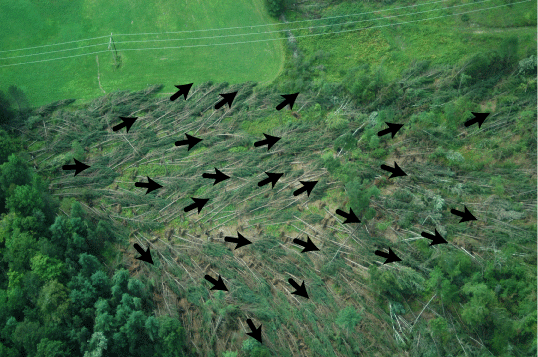 1.
1.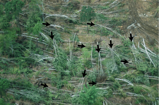 2.
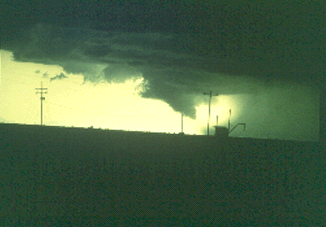
2.Which of the above two images is of tornado damage and which is of microburst damage?** See below for answer.
"During strong or severe thunderstorms, a burst of intense winds often flatten buildings and knock down trees. These winds, known as ‘downbursts’, are often mistaken for tornadoes due to the severity of the damage. A downburst features air diving toward the surface, whereas a tornado is composed of rising air."
From: http://www.usatoday.com/weather/ tg/wdnburst/wdnburst.htm
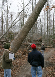
A microburst felled this THREE TO FOUR FOOT DIAMETER HARDWOOD TREE. Worried about burst just messing your kite gear up?! Think again.
"Recall that a downburst is defined as strong downdraft with an outrush of damaging winds on or near the ground. Downbursts are subdivided based on their size. If the swath of damaging winds is 2.5 miles or greater in diameter, then it is termed a macroburst. If the swath is less than 2.5 miles, it is called a microburst. In general, microbursts are quick hitting events and are extremely dangerous to aviation. Microbursts are sub-classified as dry or wet microbursts, depending on how much or little rain accompanies the microburst when it reaches the ground."
From: http://spotterguides.us/advanced/advanced06.htm
Dry microbursts seem to be more prevalent in the interior states of the American west while the wet variety may be found in coastal areas.

An animated gif of a burst.
From: http://www.exn.ca/news/images/1999/06/0 ... stanim.gif

"Microbursts can occur anywhere convective weather conditions (thunderstorms, rain showers or virga) occur. Virga is rain that evaporates before it reaches the ground and is associated with a dry Microburst. Observations suggest that approximately five percent of all thunderstorms produce a microburst.
The Microburst can occur without rain ever reaching the ground as in the case of virga. The rain will evaporate and cause a cooling in the air, which causes the downdraft." Above is a diagram of a virga caused Microburst.
The life span of a Microburst is around 15-20 minutes. Here is a life cycle diagram of the Microburst.
From: http://www.math.unl.edu/~jfisher/NSF_96/windshear.html
An example of a four photo Dry Microburst appears at the link below. This one was associated with Virga and only put out winds estimated to be 50 kts. You can see the dust blown up on the ground associated with the down flow.
CLICK HERE AND HIT SLIDESHOW
From: http://www.cimms.ou.edu/~doswell/microb ... tions.html
A good visual guide to severe weather appears at: http://www.abc.net.au/newcastle/stories ... 069538.pdf
A good reference on microbursts is at: http://www.cimms.ou.edu/~doswell/microb ... dbook.html
Another reference can be found at:
http://www.hprcc.unl.edu/nebraska/wind_events.html
and at:
http://www.ll.mit.edu/AviationWeather/wolfson.pdf
** Answer: Photo 1 is of microburst damage. Sometimes the outflow of microbursts in symmetical and linear resulting in the violent wind coming from one direction instead of several. Photo 2 is of tornado damage with a more caotic wind flow. Tornados can generate winds up to 300 mph, microbursts up to around 170 mph. The damage looks fairly similar.
FKA, Inc.
transcribed by;
Rick Iossi
WHAT TO LOOK FOR?
Check and carefully evaluate your local weather and weather hazard forecast before kiteboarding, ALWAYS.
Such as:
http://nws.noaa.gov/ (USA)
http://www.weatheroffice.com (Canada)
along with other various services in other countries. Learn what is available in your area and USE IT.
Some other ideas on weather planning can found at:
http://fksa.org/viewtopic.php?t=130
"Some of the clues but not necessarily all visual indications that a microburst may be forming are:
* Patches of virga mark potential microburst areas. As the precipitation evaporates, it cools the air and starts a downdraft. If the conditions are right, the downdraft may accelerate and reach the ground as a microburst. Localized areas or rings of blowing dust raised from the ground usually mark the impact point of dry microburst."
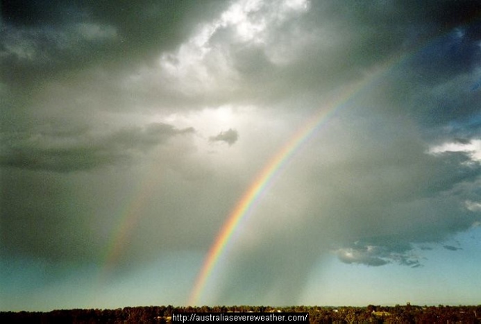
From: http://australiasevereweather.com/
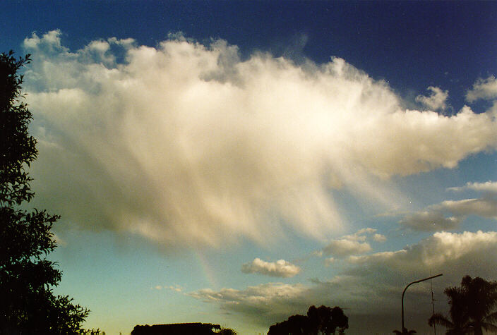
Examples of virga, there are still other variations. Virga falling precipitation that evaporates before reaching the ground.
"* A small, intense, globular rain area, with an area of lighter rain in its wake, may mark a wet microburst. A rain foot, a marked outward distortion of the edge of the precipitation area, is usually a visual indicator of a possible wet microburst. As the microburst reaches the ground and moves away from its impact point, a plume of dust may be raised from the ground. This plume is called a dust foot and also marks a possible microburst."
From: http://spotterguides.us/advanced/advanced06.htm
An example of a rain foot. From: http://ww2010.atmos.uiuc.edu/
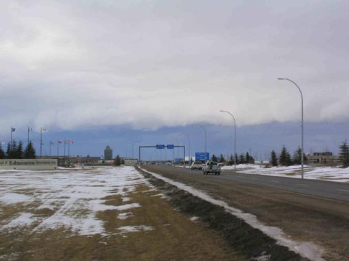
An example of a shelf cloud which can be accompanied by violent winds, tornados and microbursts. This photo was taken near the area of the snowkiteboarder fatality in Alberta, Canada on the same day.
From:
http://www.umanitoba.ca/faculties/envir ... /main.html
It is best to avoid kiteboarding when warnings of violent weather or downbursts have been made. The wet variety are not that uncommon with tropical weather systems, in feeder bands and other storm components. That is to say, THE HAZARD IN HURRICANES AND RELATED WEATHER IS HIGH! Feeder bands from hurricanes can be hundreds of mile long and can be filled with violent squalls. So even if the hurricane is a long distance from you a feeder band might be sweeping over your area.
Work to avoid downbursts. Reacting after they visually appear in your area is a fairly dangerous proposition.
FKA, Inc.
transcribed by:
Rick Iossi